This project is part of the Armadale Line Transformation.
Project
Victoria Park-Canning Level Crossing Removal
![]() Beckenham, Cannington, Carlisle, Queens Park, Victoria Park, Welshpool
Beckenham, Cannington, Carlisle, Queens Park, Victoria Park, Welshpool
Overview
-

Rail
Project type -

$1.62 billion
Total budget -

Complete
Project phase -

METRONET
Lead agency
-

4375
Jobs supported
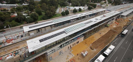
The Victoria Park-Canning Level Crossing Removal project has delivered five new elevated stations to improve public transport safety, reduce traffic congestion and create versatile community spaces.
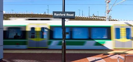
The new and modern elevated stations are in operation at Carlisle, Oats Street, Queens Park, Cannington and Beckenham stations.
For information on related rail and bus services, visit Transperth.
Six level crossings were removed along the Armadale Line and all boom gates at level crossings between Victoria Park and Beckenham have been been dismantled. Welshpool Station has permanently closed.
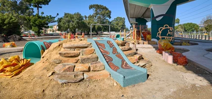
Long Park has been delivered as part of this project. Stretching seven kilometres, the six-hectare Long Park features 14 community spaces, including a public art trail, playgrounds, skate parks, dog and fitness parks and youth plazas with sports courts. New shared paths have also been built throughout the parkland area.
During the Armadale Line closure, the Public Transport Authority also delivered the Rail Revitalisation Program, undertaking major maintenance and upgrades between Kenwick and Sherwood stations. The work includes the renewal of 15 kilometres of track, 25 pedestrian crossings,10 level crossings, and improved drainage systems.
For more information, visit METRONET.


Benefits
-
 Increased safety for people and vehicles travelling in the area.
 -
Improved traffic flow and reduced time waiting at boom gates.
-
Modern station facilities and improved accessibility.
-
Public community spaces.
Gallery
-
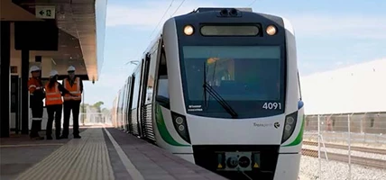
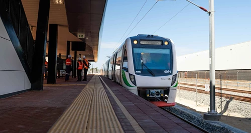
First look at the five new stations along the Victoria Park-Canning Level Crossing Removal project.
-
Hamilton Street intersection in Queens Park is now open as part of the Victoria Park-Canning Level Crossing Removal Project.
-
Oats Street Station on the Victoria Park-Canning Level Crossing Removal is nearing completion.
-
New intersections at Wharf Street (pictured), Welshpool Road and Hamilton Street are now open as part of the Victoria Park-Canning Level Crossing Removal Project.
-
Wharf Street intersection location before works commenced as part of the Victoria Park-Canning Level Crossing Removal Project.
-
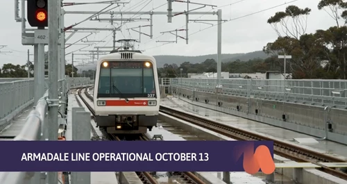
Video: Reshaping WA Report. Passenger services on the Armadale Line will commence from Monday 13 October.
-
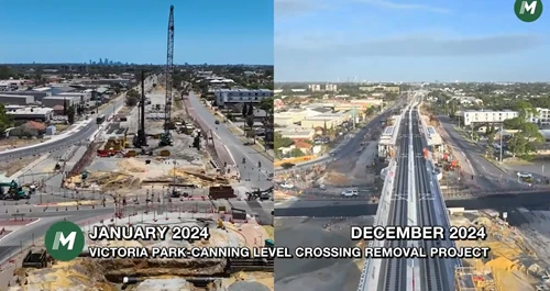
Video: Victoria Park-Canning Level Crossing Removal Project progress - January 2024 versus December 2024.
-
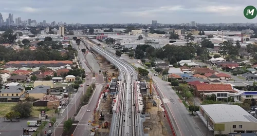
Progress has been made across the five new elevated stations on the Armadale Line and the seven-kilometre linear park beneath.
-
Video: Testing has commenced on the Thornlie-Cockburn Link and Victoria Park-Canning Level Crossing Removal Project, with the first test train successfully running from Nicholson Road to Carlisle station.
-
Artist impression of the Queens Park Station.
-
Artist's impression of the seven kilometre linear park which will run under the elevated Armadale Line.
-
One hundred per cent of the train tracks have been laid as part of the Victoria-Park Level Crossing Removal Project.
-
Video: Reshaping WA Report - Morley-Ellenbrook Line and Victoria Park-Canning Level Crossing Removal (October 2024 Update).
-
Video: Victoria Park-Canning Level Crossing Removal Project Flyover (October 2024).
-
100 per cent of elevated rail viaduct is complete on the Victoria Park-Canning Level Crossing Removal project.
-
Video: L-beams lifted over Water Corporation assets during the closure of Sevenoaks Street in Beckenham
-
Video: Timelapse of the elevated rail lift at Hamilton Street (Victoria Park-Canning Level Crossing Removal).
-
Beams being lifted into place over Queens Park Station
-
First L-beams at Carlisle Station
-
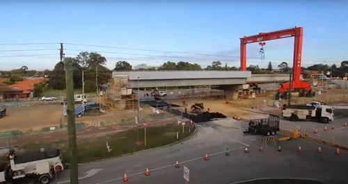
All four gantry cranes are up and running, and have lifted their first precast concrete pier for new elevated rail
-
Pier installation near Carlisle Station as part of the Victoria Park-Canning Level Crossing Removal project.
-
Piling works underway at Carlisle Station.
-
How gantry cranes are assisting the Victoria Park-Canning Level Crossing Removal
-
Arrival of the first of four gantry cranes to assist with construction of elevated rail
-
As part of the METRONET Victoria Park-Canning Level Crossing Removal Project, we're building new stations, removing level crossings, elevating rail, and creating new community spaces.
-
The first pair of gantry cranes arrive in WA to be assembled as part of the Victoria Park-Canning Level Crossing Removal and Armadale Line Transformation
-
Beckenham Station (artist impression only, subject to change)
-
Beckenham Station (artist impression only, subject to change)
-
Beckenham Station (artist impression only, subject to change)
-
Beckenham Station (artist impression only, subject to change)
-
An artist impression of the new Cannington Station.
-
An artist impression of the new Queens Park Station.
-
Artist impression of public spaces at Oats Street Station.
-
Artist impression of public spaces at Carlisle Station.
-
Oats Street Level Crossing prior to removal
-
Oats Street Level Crossing pre-removal
-
Oats Street Level Crossing pre-removal
-
Oats Street Level Crossing pre-removal


Project map

Plan your journey
Avoid disruptions to your journey and plan your trip