This project is part of the Armadale Line Transformation.
Project
Byford Rail Extension New rail line
![]() Armadale, Byford
Armadale, Byford

Overview
-

Rail
Project type -

$1.33 billion
Total budget -

Complete
Project phase -

METRONET
Lead agency
-

4200
Jobs supported
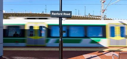
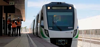
The METRONET Byford Rail Extension project has delivered a brand-new train station in Byford, a new elevated station in Armadale, and removed nine pedestrian and road-level crossings.
The major upgrades have improved connection to the public transport system with a seamless 46-minute train journey from Byford Station to the CBD.
For information on related rail and bus services, visit Transperth.
Two new over-rail bridges were also built at Thomas Road and Eleventh Road, with eight hectares of new public open space created through the elevation of the rail line.
Eight kilometres of new shared paths have also been delivered.
For more information, visit METRONET.


Benefits
-
 Provide greater transport choice and connection to the Perth CBD and wider metropolitan area.
 -
Improved safety and accessibility for public transport and shared path users.
-
New, versatile public open spaces around the new stations for the community to enjoy.
-
Modern stations and improved facilities catering to passengers’ needs and future growth.
-
Reduced traffic congestion and safer crossovers with the removal of boom gates.
Gallery
-
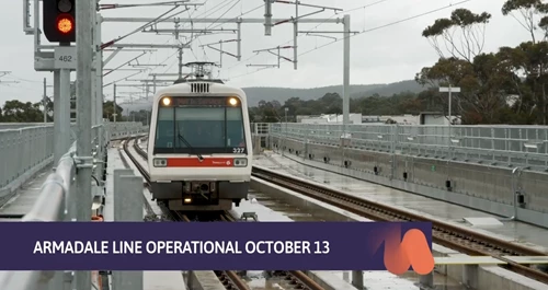
Video: Reshaping WA Report. Passenger services on the Armadale Line will commence from Monday 13 October.
-
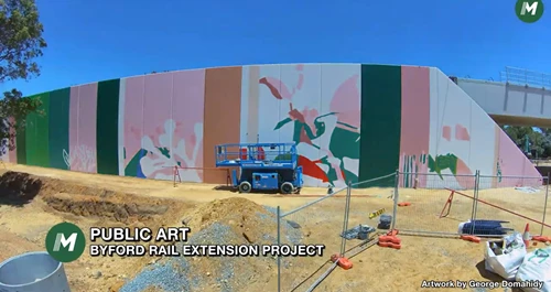
Completion works are underway on the Byford Rail Extension, including public artwork on the new Armadale Station.
-
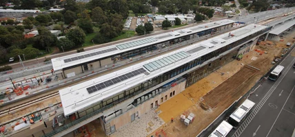
The Byford Rail Extension rail corridor infrastructure is complete.
-
Video: Reshaping WA Report (June 2025). Track for the METRONET Byford Rail Extension is fully in place and construction is advancing at both Armadale and Byford stations.
-
The track for the Byford Rail Extension Project is now 100 per cent in place.
-
Byford Station is taking shape with cladding and tiling underway on the platforms.
-
Track works are 100 per cent complete on the Byford Rail Extension Project.
-
Armadale Station is taking shape. Most of the rail and all sleepers for the Byford Rail Extension Project are now in place.
-
Video: First piece of public art has been completed on the Armadale Line Transformation (Byford Rail Extension) by WA Artist George Domahidy.
-
Art students at Armadale Senior High School worked with artist George Domahidy on part of the public art for the BRE project.
-
Byford Station has become WA's first train station to achieve a 6 Star Green Star Design Review Rating.
-
Construction of the Eleventh Road bridge for the Byford Rail Extension project corridor is progressing well, with nearly 600 Mechanically Stabilised Earth wall panels installed.
-
The BRE project is trialling a solution to reduce fossil fuels, trialling clean energy for a net-zero future with the installation of a HYDI unit.
-
The Byford Rail Extension bridge deck on the Eleventh Road road-over-rail bridge is now complete.
-
Twelve additional piles have been installed on the BRE project, completing the new pedestrian bridge over Armadale Road.
-
One kilometre of track has been laid on the Byford Rail Extension project.
-
The first 200 metres of ballast has been laid north of Eleventh Road for the Byford Rail Extension, paving the way for sleepers and track.
-
The Larsen Road pedestrian bridge on the BRE project is well undeway.
-
Track is making its debut on the Byford Rail Extension Project, with track foundation work underway and the first rail sleepers ready for installation.
-
The Eleventh Road bridge is taking shape as part of the Byford Rail Extension. These beams weigh nearly 200 tonne each and stretch over 44 metres.
-
The Larsen Road pedestrian bridge is taking shape. When complete, the bridge will connect communities on either side of the rail corridor.
-
History is being preserved with 400 pre-used railway sleepers donated to Rail Heritage WA. The sleepers will be used to re-lay 300m of track for their heritage train line (Whiteman Park Tram Extension).
-
The elevated Armadale Station is taking shape. The viaduct is 8-10m from ground level with 131 columns and 125 beams now installed.
-
The Byford Station platform canopy is taking shape. These will provide shelter for commuters.
-
This project is trialling the use of renewable diesel to help reduce its carbon footprint. Pictured is an on-site water tanker running on 100% Hydrotreated Vegetable Oil (HVO).
-
Concrete panels have been installed for the Australind and metro platforms.
-
Completed concrete pour for the Wungong Brook Bridge deck.
-
Wall panels are installed to provide structural support for the new Eleventh Road Bridge.
-
Viaduct beams are being lifted into place over Armadale Road.
-
The first viaduct beam has gone up for the elevated rail between Church Avenue and Forrest Road in Armadale.
-
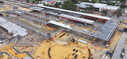
Progress continues with over 50 per cent of earthworks now complete and over half of the station platform walls installed.
-
The first of 131 columns has been lifted into place for the elevated rail along the Byford Rail Extension Project.
-
Beams for the elevated rail at Armadale under construction.
-
33 kilometres of new rail track has arrived.
-
Video: We’re building new stations at Armadale and Byford, removing level crossings, and extending the line eight kilometres to Byford.
-
Artist impression of the new Byford Station.
-
Artist impression of the new Armadale Station.
-
The new Thomas Road Bridge opened to traffic in November 2022.
-
The Byford Rail Extension will extend the Armadale Line to Byford.


Project map

Plan your journey
Avoid disruptions to your journey and plan your trip